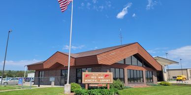
Airport Info
FAA Identifier: RGK
Lat/Long:
44-35-21.682N / 092-29-05.888W
44-35.36137N / 092-29.09813W
44.5893561 / -92.4849689
(estimated)
Elevation:
780 ft. / 237.7 m (surveyed)
Variation:
02E (1995)
Airport Operations

Airport use:
Open to the public
Sectional chart:
GREEN BAY
Control tower:
no
ARTCC:
MINNEAPOLIS CENTER
FSS:
GREEN BAY FLIGHT SERVICE STATION
[1-800-WX-BRIEF]
NOTAMs facility:
RGK (NOTAM-D service available)
Attendance:
MON-SAT 0800-1700
SUN 1000-1600
Wind indicator:
lighted
Segmented circle:
yes
Lights:
DUSK-DAWN
ACTVT HIRL RY 09/27, MALSR RY 09, ODALS RY 27, PAPI RYS 09 & 27 - CTAF
Beacon:
white-green
(lighted land airport)
Runway Information Runway 9/27
Runway Information Runway 9/27
Dimensions:
5010 x 100 ft. / 1527 x 30
Surface:
asphalt, in good condition
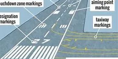
Markings:
precision, in good condition
Weight limitations:
Single wheel: 30000lbs,
Double wheel:75000lbs
Runway edge lights:
high intensity
Obstructions:
none
Elevation:
778.0 ft.
Traffic pattern:
left
Runway end identifier lights:
no
Touchdown point:
yes, no lights
RUNWAY 9
Latitude:44-35.38322N Longitude:092-29.67432W
Runway heading:089 magnetic, 091 true
Visual slope indicator:4-light PAPI on left (3.00 degrees glide path) Approach lights: MALSR: 2,400-foot medium intensity approach lighting
system with runway alignment indicator lights
Instrument approach: ILS
RUNWAY 27
Latitude: 44-35.33940N
Longitude: 092-28.52202W
Runway heading:
269 magnetic, 271 true
Visual slope indicator:
4-light PAPI on left (3.45 degrees glide path)
Approach lights:
ODALS 1,500-foot 7-lamp sequential strobes approach lighting system
Nearby radio navigation aids
Nearby radio navigation aids
Runway Information Runway 9/27
VOR radial/distance: FGTr089/29.9
VOR name: FARMINGTON VORTAC
Freq: 115.70
Var: 03E
VOR radial/distance: MSPr117/36.6
VOR name: MINNEAPOLIS VOR/DME
Freq: 115.30
Var: 03E
NDB name: HOPEY
Hdg/Dist: 128/25.9
Freq: 400
Var: 03E
ID: PPI .--. .--. ..
NDB name: NEW RICHMOND
Hdg/Dist: 174/33.5
Freq: 257
Var: 02E
ID: RNH .-. -. ....
Airport Communications
Nearby radio navigation aids
Airport Communications

GREEN BAY RCO:
122.6
CTAF/UNICOM:
123.05
WX AWOS-3P/T:
119.25 (715-594-3763)
MINNEAPOLIS APPROACH:
121.2
MINNEAPOLIS DEPARTURE:
121.2
Airport Services
Nearby radio navigation aids
Airport Communications
.jpg/:/cr=t:0%25,l:1.9%25,w:96.21%25,h:100%25/rs=w:388,h:194,cg:true)
Fuel available:
100LL & JET-A Pay at Pump 24-hours Prices available at:
https://www.globalair.com/airport/fbo-at-rgk-blue-airways-2397.aspx
Parking: hangars and tie-downs
Airframe service: MAJOR
Powerplant service: MAJOR
Oxygen Servicing: YES
Toilet Servicing: YES